Day 23
When I woke up this morning I counted 27 mosquitoes siting on the outside of my tent's mesh netting. My campsite is still in shadow. I lied in my tent waiting for suntouch to arrive and chase off the mosquitoes. Once they were gone I got out and made myself breakfast. After eating I started on trail.
I reached the trail junction to Grinnell Lake, on the opposite side of the valley from where the hanging valley of the Second Recess connects. A hanging valley is a secondary valley that joins a main valley where the latter has been deepened by glacial erosion, resulting in a steep drop from the floor of the secondary valley to the floor of the main valley. In this area there are four hanging valleys on the southern slope called recesses, first through fourth, and three on the northern slope, Pioneer Basin, Hopkins Creek and Laurel Creek.
Had I not needed to exit with Carl four days ago due to a leaky pack cover and wet toilet paper, I would have climbed down from White Bear Pass (11800), passed by Brown Bear Lake (11000) and Lake Italy (11202), climbed over Gabbot Pass (12240), and camped at one of the two Mills Creek Lakes (11167 or 10851) in the Second Recess, then I would have intersected my current position here at the trail junction of the Laurel Creek Trail (8795) that up goes to Grinnell lake (10805).
From here I turned north and began climbing steep switchbacks out of the main valley of Mono Creek. As I climbed I left the lush forest behind and manzanita, with its brilliant red branches and deep green leaves covered the mountainside with an occasional pine tree pushing its way through. To the right of the trail Laurel Creek tumbled down in cascades and the babbling of water mingled with the buzzing of the bees in the manzanita.
After a while the trail began to level out and the switchbacks ended as the trail became more direct. The creek was now in less of a hurry to go downhill. Forest closed back in around me, though not as lush as the one I had left behind, this was more open. As soon as the opportunity presented itself I refilled my water bottles. I was going to sit and rest here next to the creek in the shade but after having to swat at more than a few mosquitoes I changed my mind.
I continued following the trail that followed the creek. The trees then opened up again and gave way to meadowland, the creek now lazily meandered it's way across the terrain and the trail disappeared into the grasses. Now, I was finally cross country-ing again.
According to my map all I have to do is follow the creek and I would be good. After making my way across the meadow I came to the forest on the other side. The creek was now impossible to follow due to thick willows growing up around its steep banks. Back into the forest I went. The trail reappeared soon after entering the treeline so I continued following it. The trail soon became impossible to follow as well, due to numerous fallen trees littering the forest floor and blocking the path. The ones I could walk around I did, but it became such a interwoven mess of branches and logs that going around became much more difficult unless I strayed father and father away from the trail and the creek to where the terrain began sloping up to the mountains bordering the eastern side of this hanging valley. So I did the best I could to navigate through the sharp mess of pointy branches. As I made my way through, I broke off branches where I could to make a path I could easily follow out if I needed to.
The glimpses I got of the other side of the creek looked open and free of trees, so I aimed to find a route that would take me over to the creek where I could easily cross. That is easier said than done. In my attempts to reach the creek I had to double back more that a few times. By the time I finally reached the creek I had emerged on the other side of all the fallen trees. The lazy stream had awoken and was now crashing over rocks and a waterfall lay ahead of me. On the far side is a cliff face with black stains that indicate that it is a waterfall at times, right now it is just a trickle.
The trail was again nowhere to be seen. According to my map there are two smaller creeks that converge with the main one. The first flows down from a small tarn that I looked at on Google Earth before I left and that looked interesting for photography opportunities. The second smaller creek intersected at the same place as a trail junction, one way takes the backpacker to Grinnell Lake and the other to Laurel Lake. There is no trail that I can see and since I wasn’t able to follow the creek as closely as I had wanted to, I don’t know if this is the first or second smaller creek. I'm not sure if I want to stay at Grinnell Lake, Laurel Lake or the small tarn tonight. It won't really make a difference because all three will get me to tomorrow's destination, Cotton Lake.
After much deliberation I have decided to take a chance and climb up the dry waterfall on the far side then follow that creek to where ever it goes. Hopefully I wont get lost and have to double back. I began free climbing up the cliff face, it's not as steep as it looked. After reaching the top of that the terrain sloped steeply up, then the slope became more gradual. I followed the creek that was flowing in some places and not others. Finally the slope leveled out and shortly after I reach a rock-ringed tarn. A short distance away was a lake. This must be Laurel Lake, its too big to be the small tarn.
I dropped pack here and ate lunch; cheese, salami, a slice of dried chilli mango, a handful of smoked almonds and a few scoops of peanut butter. Then I laid down on some soft grass in the shade of a crooked pine tree and took a nap.
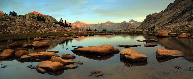
After waking up I walked back to the rock-ringed tarn, took a few pictures *1 and continued back to where the terrain began to slope down. Here, there was a spectacular view, *2 one that rivals and far surpasses the tunnel view that greets visitors to Yosemite. Immensity in all it's grandeur. I could see the hanging valley of the Second Recess far off in the distance on the other side of Mono canyon, with Mt. Hilgard (13361) and Mt. Gabb (13741) rising beyond it. The hanging valley I had just hiked through stretched out below me and then rose up to where I sat as I took in the view. (Much later, after I returned home and I was talking to one of my backpacking companions, who was unable to join me on this journey, I described the view as better than the tunnel view in Yosemite, he argued against it, saying that that was a very bold statement, because from there one can see all the major landmarks, Half Dome, El Capitan, the Three Sisters, etc. I explained that when I am at the tunnel view in Yosemite, its hard to really enjoy the experience because you are surrounded by a hundred people all talking and making tons of noise, being disrespectful and leaving their trash just lying around and sometimes blasting music from their cars. While on the road just behind you cars are constantly rushing by and the smell of their exhaust fills the air. But when I was here, I was alone, no one to spoil the silence, no car exhaust to breathe in, no trash, no man made anything. It was just me with the wind, the rocks, the trees, the mountains, the sky, a chipmunk, and a falcon circling overhead eyeballing that chipmunk.)
As the sun sank lower in the sky and the shadows grew longer a cold wind swirled up from the valley below. I then retreated back to the lake and my pack and made some tea. Then I headed back to the rock-ringed tarn to photograph sunset *3 while sipping on hot jasmine tea.
I didn't see a single person all day, and since there are no mosquitoes up here I will not be using my tent.