Understanding that earthwork mounds of collected rocks (cairns) or soil and rock mixes (barrows and tumuli) date back to the 'Tells' or 'Tepe' of the fertile crescent, and the pre pottery Neolithic/epipaleolithic hinterland before reaching out through time to carry past the first examples of western Europe (for example the above long barrow/Tumulus allongé) and then through the ages of protohistory and into the early Medieval period with, for example Anglo Saxon tumuli of the 7th century AD. Was there a faint continuity as memory walked in ever longer circles from 9,000 ybp east to 5,000 ybp west, or should we look with an optic of a 'parallel evolution' of approximative form between the initial Tells and an ignition of the local area passage graves and giant cairns along the European Atlantic coast?
There are myriad ways to date artificial mounds as they shifted their 'footprint', silhouette and armatures over region and time. For this extended case study I will employ the term Artificial Pedestal landmark, looking at what went in, and what went on.
Strong Dolmens, tunnel like Allée couverte (passage tombs), wooden boxes, cists, basin stones (for cremated ash) and urn fields can all be found inside earthwork mounds at one point of time or other, as can 'unchambered long barrows' or artificial mounds without internal detailing. Today, there are clear example of dolmens without covering tumuli and I used to be among those who argued that the tumuli was optional. Understanding the ease of decommissioning a pagan site by removing its pedestal has tipped me to think that tumuli were the finished state.
At first glance, the interior dolmenic forms might seem to atrophie with time, which is almost true, were it not for certain grandiose allee couverte, and regional differences including megalithic-boat forms armatures and late initiation megalitism.
"The earliest long barrows/Tumulus allongé date to around 6800 ybp (Barnenez). The early passage graves generally date to between 4000 and 3000 bc, followed by evolved passage graves between 3000-2500 bc. In the later part of the Neolithic, allées couvertes and simple dolmens became the predominant type of burial monument. Some passage graves are decorated with incised lines, of which Gavrinis is probably the best known example." (Wiki)
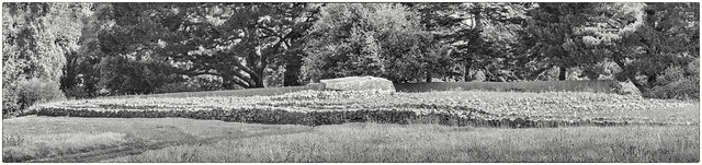
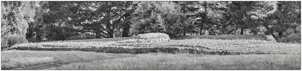
Regarding the above Er Grah tumuli, it seems that for around 500 years, from 6500 years ago, the loci of this great tumulus stuttered and grew with modesty untill a burst into the current form that can be known as a passage grave or long barrow or tumulus allongé. Whilst the final length is said to reach 140m metres, much of the length seems to be an extended platform so potentially an atypical addition to envelope and qualify gathered onlookers whilst decorating the landscape with visual meaning: onlookers gathered to participate in culture (from religion to festivity and from ceremony to remembrance) with the sumit of the tumuli being the pedastle for the visual and acoustic elements and the secure chamber being the watertight hold for rare items of carve, weave, colour and peoples past.
Once landed onto its frame, a 'Transport Dragon' lowers its carriers to a crouch.
Protected by Heritage law in 1935, the site was an overgrown carpark by the 1960s: 'Simca Arondes' parked over the tumuli with picnic crums and 'Pouss Pouss' sticks. The site had also been used as a source for stone so its silhouete may never be known as removing stones in a systematic might exagerate and formalise the modest steps that report today.
If these early long tumuli are to be hypothesised as pedastles then a long feature that might benefit from being lifted into prominance needs to be qualified and this will be covered in future posts.
The tumulus of Er Grah is from an unthreaded cluster of rare megalithic giants. The Tumulus d'Er Grah (pictured above) watches the adjacent Table de Marchand (linked below), a giant megalith and yet just 100 metres away: which in turn sits aside the almighty broken-blocks that remain from the super giant menhir of Er Grah. Looking one kilometer away in the opposite northern direction, and the Tumulus du Mané-Lud hides its equally rare corridor and rooms. Four kilometres east and the Island of Gavrinis lifts its charming ramped tumuli and hidden corridor of sheer and preserved petroglyphic treasure; and a jog to the Quiberon bay and the 'Les Pierres Plates' hides its extraordinary double corridor behind a polite menhir topped by gull. The element that links this diverse cluster of giant cairns is Neolithic petroglyphic rock art, and the artwork is both themed and very divergent between these sites.
Elsewhere in Europe there are the famouse Neolithic Irish carvings of Newgrange circa 5200 ybp, and the plethora of rock art, often known as 'cup and ring', and found in regions of Spain, England, Portugal, Italy, France... For this schematic work, the upper date range warms into the Iron age and the lower range is often quoted as late Neolithic to Bronze age. These erratic carved outcrops are so difficult to date that one might suspect that some examples dive deeper into the Neolithic and even surprise with dates closer to the Locmariaquer cluster (or the Brú na Bóinne cluster) - but confirmation of an early surprise is waiting and as yet there are no stones I know of from near to the the date range of this cluster.
Stepping back, megaliths can show occasional and at times elaborate cup and ring style ornament and even carvings of tools, elaborate statue menhirs or schematic painted surface, but as a rule, despite these exceptions, the stone surfaces of dolmens, menhirs, curb stones and row stones are either raw or finished and nothing more. To have a cluster of megaliths with a range of carved inscription in a single local area is not the norm - a further indication that the greater area; between styles of bay, vigorous stream and endless sea, was a special place.
It can also be registered that the other cluster of Western European rock art from the early Neolithic, that of Brú na Bóinne (Newgrange, Knowth, and Dowth) was tidal in the Neolithic and the river Matock was vigorous enclosing the site with manifestations of the subject of water. The Irish sea was down river and the wider coastal mouth provided curb ornament of quartz and galle granite from a coastal length of around 130km.
AJM 11.03.23
19.03.23