I visited Urquhart Castle today Friday 27th July 2018 on a magnificent summers day with temperatures reaching a scorching 30 degrees , very unusual for Scotland.
The castle is beautiful sitting on cliffs overlooking Loch Ness, I have put some information on the castles history below.
Urquhart Castle , Scottish Gaelic: Caisteal na Sròine) sits beside Loch Ness in the Highlands of Scotland. The castle is on the A82 road, 21 kilometres (13 mi) south-west of Inverness and 2 kilometres (1.2 mi) east of the village of Drumnadrochit.
The present ruins date from the 13th to the 16th centuries, though built on the site of an early medieval fortification. Founded in the 13th century, Urquhart played a role in the Wars of Scottish Independence in the 14th century. It was subsequently held as a royal castle, and was raided on several occasions by the MacDonald Earls of Ross.
The castle was granted to the Clan Grant in 1509, though conflict with the MacDonalds continued. Despite a series of further raids the castle was strengthened, only to be largely abandoned by the middle of the 17th century. Urquhart was partially destroyed in 1692 to prevent its use by Jacobite forces, and subsequently decayed. In the 20th century it was placed in state care as a scheduled monument and opened to the public: it is now one of the most-visited castles in Scotland.
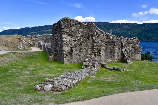
The castle, situated on a headland overlooking Loch Ness, is one of the largest in Scotland in area. It was approached from the west and defended by a ditch and drawbridge. The buildings of the castle were laid out around two main enclosures on the shore.
The northern enclosure or Nether Bailey includes most of the more intact structures, including the gatehouse, and the five-story Grant Tower at the north end of the castle. The southern enclosure or Upper Bailey, sited on higher ground, comprises the scant remains of earlier buildings.
Description
Urquhart Castle is sited on Strone Point, a triangular promontory on the north-western shore of Loch Ness, and commands the route along this side of the Great Glen as well as the entrance to Glen Urquhart.
The castle is quite close to water level, though there are low cliffs along the north-east sides of the promontory. There is considerable room for muster on the inland side, where a "castle-toun" of service buildings would originally have stood, as well as gardens and orchards in the 17th century.
Beyond this area the ground rises steeply to the north-west, up to the visitor centre and the A82. A dry moat, 30 metres (98 ft) across at its widest, defends the landward approach, possibly excavated in the early Middle Ages. A stone-built causeway provides access, with a drawbridge formerly crossing the gap at the centre.[37] The castle side of the causeway was formerly walled-in, forming an enclosed space similar to a barbican.
Urquhart is one of the largest castles in Scotland in area.
The walled portion of the castle is shaped roughly like a figure-8 aligned northeast-southwest along the bank of the loch, around 150 by 46 metres (492 by 151 ft),forming two baileys (enclosures): the Nether Bailey to the north, and the Upper Bailey to the south.
The curtain walls of both enclosures date largely to the 14th century, though much augmented by later building, particularly to the north where most of the remaining structures are located.
Nether Bailey
The 16th-century gatehouse is on the inland side of the Nether Bailey, and comprises twin D-plan towers flanking an arched entrance passage. Formerly the passage was defended by a portcullis and a double set of doors, with guard rooms either side. Over the entrance are a series of rooms which may have served as accommodation for the castle's keeper.Collapsed masonry surrounds the gatehouse, dating from its destruction after 1690.
The Nether Bailey, the main focus of activity in the castle since around 1400,is anchored at its northern tip by the Grant Tower, the main tower house or keep. The tower measures 12 by 11 metres (39 by 36 ft), and has walls up to 3 metres (9.8 ft) thick.
The tower rests on 14th-century foundations, but is largely the result of 16th-century rebuilding.
Originally of five storeys, it remains the tallest portion of the castle despite the southern wall collapsing in a storm in the early 18th century. The standing parts of the parapet, remodelled in the 1620s, show that the corners of the tower were topped by corbelled bartizans (turrets).
Above the main door on the west, and the postern to the east, are machicolations, narrow slots through which objects could be dropped on attackers. The western door is also protected by its own ditch and drawbridge, accessed from a cobbled "Inner Close" separated from the main bailey by a gate.
The surviving interior sections can still be accessed via the circular staircase built into the east wall of the tower. The interior would have comprised a hall on the first floor, with rooms on another two floors above, and attic chambers in the turrets. Rooms on the main floors have large 16th-century windows, though with small pistol-holes below to allow for defence.
To the south of the tower is a range of buildings built against the thick, buttressed, 14th-century curtain wall. The great hall occupied the central part of this range, with the lord's private apartments of great chamber and solar in the block to the north, and kitchens to the south.
The foundations of a rectangular building stand on a rocky mound within the Nether Bailey, tentatively identified as a chapel.
Upper Bailey
The Upper Bailey is focused on the rocky mound at the south-west corner of the castle. The highest part of the headland, this mound is the site of the earliest defences at Urquhart. Vitrified material, characteristic of early medieval fortification, was discovered on the slopes of the mound, indicating the site of the early medieval fortification identified by Professor Alcock. In the 13th century, the mound became the motte of the original castle built by the Durwards, and the surviving walls represent a "shell keep" (a hollow enclosure) of this date. These ruins are fragmentary, but indicate that there were towers to the north and south of the shell keep.
A 16th-century water gate in the eastern wall of the Upper Bailey gives access to the shore of the loch.
The adjacent buildings may have housed the stables.
To the south of this, opposite the motte, is the base of a doocot (pigeon house) and the scant remains of 13th-century buildings, possibly once a great hall but more recently re-used as a smithy.