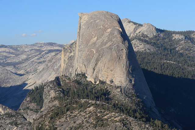
Half Dome seen from Washburn Point
Half Dome vom Washburn Point gesehen
Half Dome is a granite dome at the eastern end of Yosemite Valley in Yosemite National Park, California. It is a well-known rock formation in the park, named for its distinct shape. One side is a sheer face while the other three sides are smooth and round, making it appear like a dome cut in half. The granite crest rises more than 4,737 ft (1,444 m) above the valley floor.
The impression from the valley floor that this is a round dome that has lost its northwest half is an illusion. From Washburn Point, Half Dome can be seen as a thin ridge of rock, an arête, that is oriented northeast-southwest, with its southeast side almost as steep as its northwest side except for the very top. Although the trend of this ridge, as well as that of Tenaya Canyon, is probably controlled by master joints, 80 percent of the northwest "half" of the original dome may well still be there.
As late as the 1870s, Half Dome was described as "perfectly inaccessible" by Josiah Whitney of the California Geological Survey.[4] The summit was finally reached by George G. Anderson in October 1875, via a route constructed by drilling and placing iron eyebolts into the smooth granite.
Today, Half Dome may now be ascended in several different ways. Thousands of hikers reach the top each year by following an 8.5 mi (13.7 km) trail from the valley floor. After a rigorous 2 mi (3.2 km) approach, including several hundred feet of granite stairs, the final pitch up the peak's steep but somewhat rounded east face is ascended with the aid of a pair of post-mounted braided steel cables originally constructed close to the Anderson route in 1919.
Alternatively, over a dozen rock climbing routes lead from the valley up Half Dome's vertical northwest face. The first technical ascent was in 1957 via a route pioneered by Royal Robbins, Mike Sherrick, and Jerry Gallwas, today known as the Regular Northwest Face. Their five-day epic was the first Grade VI climb in the United States. Their route has now been free climbed several times in a few hours' time. Other technical routes ascend the south face and the west shoulder.
The Half Dome Cable Route hike runs from the valley floor to the top of the dome in 8.2 mi (13 km) (via the Mist Trail), with 4,800 ft (1,460 m) of elevation gain. The length and difficulty of the trail used to keep it less crowded than other park trails, but in recent years the trail traffic has grown to as many as 800 people a day. The hike can be done from the valley floor in a single long day, but many people break it up by camping overnight in Little Yosemite Valley. The trail climbs past Vernal and Nevada Falls, then continues into Little Yosemite Valley, then north to the base of the northeast ridge of Half Dome itself.
The final 400 ft (120 m) ascent is steeply up the rock between two steel cables used as handholds. The cables are fixed with bolts in the rock and raised onto a series of metal poles in late May (the poles do not anchor the cables). The cables are taken down from the poles for the winter in early October, but they are still fixed to the rock surface and can be used. The National Park Service recommends against climbing the route when the cables are down and when the surface of the rock is wet and slippery. The Cable Route is rated class 3, while the same face away from the cables is rated class 5.
The Cable Route can be crowded. In past years, as many as 1,000 hikers per day have sometimes climbed the dome on a summer weekend, and about 50,000 hikers climb it every year.
Since 2011, all hikers who intend to ascend the Cable Route must now obtain permits before entering the park. Permits are checked by a ranger on the trail, and no hikers without permits are allowed to hike beyond the base of the sub-dome or to the bottom of the cables. Hikers caught bypassing the rangers to visit either the sub-dome or main dome without a permit face fines of up to $5,000 and/or 6 months in jail.
Backpackers with an appropriate wilderness permit can receive a Half Dome permit when they pick up their wilderness permit with no additional reservation required. Rock climbers who reach the top of Half Dome without entering the subdome area can descend on the Half Dome Trail without a permit.
The top of Half Dome is a large, flat area where climbers can relax and enjoy their accomplishment. The summit offers views of the surrounding areas, including Little Yosemite Valley and the Valley Floor. A notable location to one side of Half Dome is the "Diving Board", where Ansel Adams took his photograph "Monolith, The Face of Half Dome" on April 10, 1927. Often confused with "the Visor," a small overhanging ledge at the summit, the Diving Board is on the shoulder of Half Dome.
From 1919 when the cables were erected through 2011, there have been six fatal falls from the cables. The latest fatality occurred on May 21, 2018.
Lightning strikes can be a risk while on or near the summit. On July 27, 1985, five hikers were struck by lightning, resulting in two fatalities.
The Cable Route was added to the National Register of Historic Places in 2012.
Half Dome was originally called "Tis-sa-ack", meaning Cleft Rock in the language of the local Ahwahnechee people. Tis-sa-ack is also the name of the fourth route on the formation, ascended by Royal Robbins and Don Peterson over eight days in October 1969. Tis-sa-ack is the name of a mother from a native legend. The face seen in Half Dome is supposed to be hers. Tis-sa-ack is the name of a Mono Lake Paiute Indian girl in the Yosemite Native American legend. John Muir referred to the peak as "Tissiack".
Others say Ahwahneechee Native Americans named Half Dome “Face of a Young Woman Stained with Tears” ("Tis-se’-yak") because of the colonies of brown-black lichens that form dark vertical drip-like stripes along drainage tracks in the rock faces.
In 1988, Half Dome was featured on a 25 cent United States postage stamp. An image of Half Dome, along with John Muir and the California condor, appears on the California State Quarter, released in January 2005. Starting October 2010, an image of Half Dome is included on the new revised California drivers license in the top right-hand corner.
In 2014, Apple revealed their new version of their operating system, Yosemite, and Half Dome was the default wallpaper on the new macOS.
Half Dome is also an element or inspiration of various company and organization logos, including that of The North Face, Sierra Designs, & Mountain Khakis outdoor product companies, the Sierra Club environmental group and the Sierra Entertainment game studio.
In 2015, American music artist Toro y Moi, real name Chazwick Bundick, released a song called 'Half Dome' from his album 'What For?'. The song was inspired by a hike he took up the dome. On the hike he happened to meet photographer R. Adam Prieto who was a fan of Bundick's music. Prieto agreed to create the music video for 'Half Dome'. The video features time-lapse videos of the dome and surrounding area.
(Wikipedia)
Der Half Dome (auch Ti-sa-ach in der Sprache der Ahwahnee) ist ein 2693 m hoher Berg im Yosemite-Nationalpark im US-Bundesstaat Kalifornien. Er liegt am östlichen Ende des Yosemite Valley. Seit der Fotograf Ansel Adams 1927 den Berg mit seiner charakteristischen Halbkugelform auf einer seiner berühmtesten Aufnahmen (Monolith, The Face of Half Dome) einem breiten Publikum bekannt gemacht hatte, ist er das Wahrzeichen des Nationalparks und stellt zusammen mit dem El Capitan eines der meistfotografierten Motive dar.
Der Half Dome besteht aus Granodiorit. Der Half-Dome-Granodiorit ist ein sehr massives Gestein, das kaum von steilstehenden Kluftscharen durchzogen wird (im Gegensatz beispielsweise zum Cathedral-Peak-Granodiorit). Seine gerundeten Formen in Gipfelnähe entstanden durch Desquamation. Seine senkrechte, dem Tal zugewandte Nordwestflanke lässt sich durch einen relativ kleinen eiszeitlichen Gletscher oberhalb des Mirror Lake erklären, der diese Bergseite durch Frostsprengung unterminierte und überhängende Partien bis zum Verlauf einer größeren, Nordost-Südwest-streichenden Störungs- oder Hauptkluftfläche nachstürzen ließ.
Jedes Jahr besteigen Tausende Touristen den Berg. Der Gipfel des Half Dome kann über den Normalweg bei entsprechender Kondition erreicht werden. Für die etwa 25 km Wegstrecke und annähernd 1500 Höhenmeter im Auf- und Abstieg benötigen geübte Wanderer acht bis zwölf Stunden.
Auf den letzten 120 Höhenmetern ermöglichen Drahtseile den weniger geübten Bergsteigern, eine Steigung von bis über 45° bzw. 100 % auf dem glatten, ungestuften Granodiorit zu bewältigen. Dazu wurden bereits 1919 Löcher in den Fels gebohrt, in die im Sommer senkrechte Stützen gesteckt werden. Die Drahtseile werden von diesen auf etwas über Hüfthöhe gehalten. Außerdem liegen auf dem Fels an den Stützen Holzbohlen, die dem Fuß Halt bieten. Im Winter werden Stützen und Bohlen entfernt. Von einem Aufstieg ist in diesem Fall, ebenso wie bei Nässe oder Gewitterneigung, dringend abzuraten. Bis 2007 gab es keinen bekannten tödlichen Unfall an den Stahlseilen, seitdem kamen jährlich mehrere Menschen ums Leben.
Seit Anfang 2010 ist für die Besteigung des Gipfels eine Registrierung notwendig, deren Anzahl pro Tag begrenzt ist.
Der Half Dome kann auch frei kletternd bestiegen werden, mehrere Routen führen über die nahezu senkrechte Nordwestwand oder die gerundeten Flanken. 1957 wurde die Nordwestwand erstmals von Royal Robbins zusammen mit Jerry Gallwas und Mike Sherrick begangen. Dies war die erste Kletterei im „Grad VI“ in Amerika.
Durch eine Aufnahme (Monolith, the Face of Half Dome) des amerikanischen Fotografen Ansel Adams im Jahre 1927 erlangte der Half Dome große Bekanntheit. Der Half Dome wird in stilisierter Form von einer Vielzahl an Unternehmen als Logo verwendet, darunter der Hersteller von Bergsport- und Outdoorbekleidung und -ausrüstung The North Face. Apple verwendet den Half Dome im Betriebssystem OS X Yosemite (Yosemite) in einer Reihe von Hintergrundbildern und Werbekampagnen.
(Wikipedia)