Schweiz / Wallis - Aletschgletscher
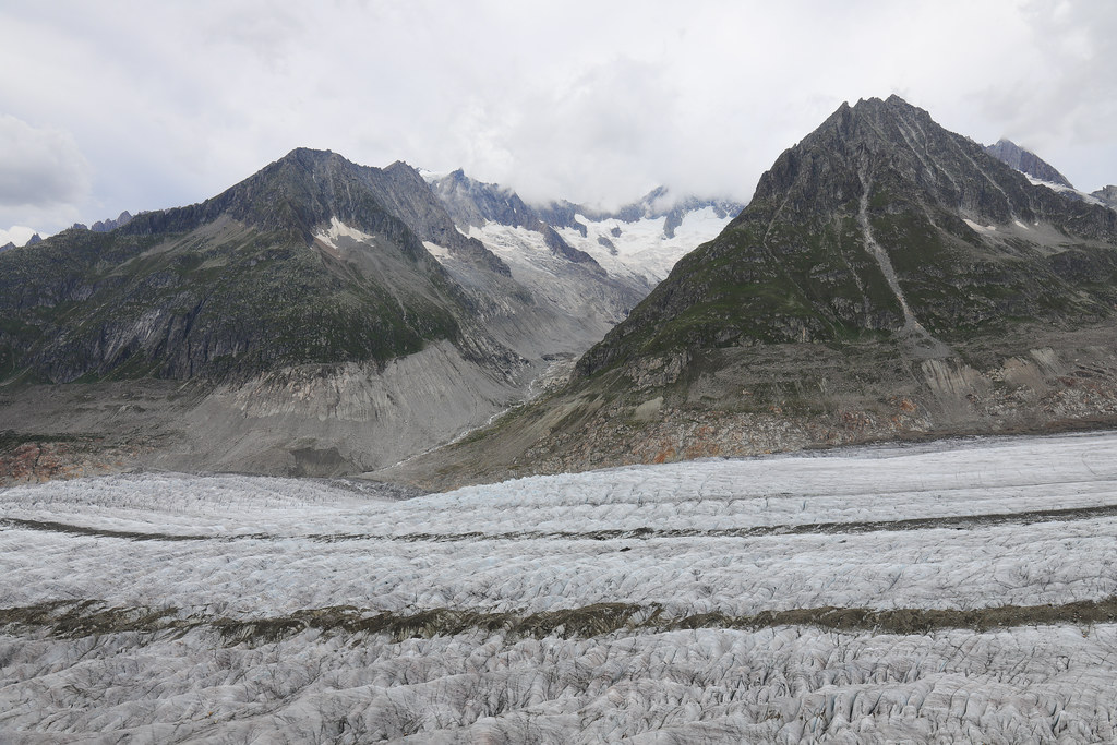
In the background you can see the Mittelaletsch Glacier and the Olmenhorn (3,314 m) (right).
Im Hintergrund sieht man den Mittelaletschgletscher und das Olmenhorn (3.314 m) (rechts).
The Aletsch Glacier (German: Aletschgletscher, German pronunciation: [ˈalɛtʃˌɡlɛtʃɐ]) or Great Aletsch Glacier (Grosser Aletschgletscher) is the largest glacier in the Alps. It has a length of about 23 km (14 mi) (2014), has about a volume of 15.4 km3 (3.7 cu mi) (2011), and covers about 81.7 km2 (31.5 square miles) (2011) in the eastern Bernese Alps in the Swiss canton of Valais. The Aletsch Glacier is composed of four smaller glaciers converging at Konkordiaplatz, where its thickness was measured by the ETH to be still near 1 km (3,300 ft). It then continues towards the Rhône valley before giving birth to the Massa. The Aletsch Glacier is – like most glaciers in the world today – a retreating glacier. As of 2016, since 1980 it lost 1.3 kilometres (0.81 mi) of its length, since 1870 3.2 kilometres (2.0 mi), and lost also more than 300 metres (980 ft) of its thickness.
The whole area, including other glaciers is part of the Jungfrau-Aletsch Protected Area, which was declared a UNESCO World Heritage Site in 2001.
Geography
The Aletsch Glacier is one of the many glaciers located between the cantons of Bern and Valais on the Bernese Alps located east of the Gemmi Pass. The whole area is considered to be the largest glaciated area in western Eurasia. The Fiescher and Aar Glaciers lying on the east have similar extensions.
Except the Finsteraarhorn, all the highest summits of the Bernese Alps are located within the drainage basin of the glacier. The Jungfrau and Mönch constitute the northern boundary; the Gross Fiescherhorn and Gross Wannenhorn lie on its east side; finally the culminating point, the Aletschhorn (4,193 m (13,757 ft)) is located on the west side.
Before reaching the maximum flow, four smaller glaciers converge at Konkordiaplatz:
From the western mouth flows the Grosser Aletschfirn, which runs along the northern foot of the Aletschhorn and Dreieckhorn. The Grosser Aletschfirn is supplied from the north by three notable firns: the Äbeni Flue-Firn, the Gletscherhornfirn, and the Kranzbergfirn. All of these firns have their starting points at around 3,800 m (12,500 ft). From the Äbeni Flue-Firn to the Konkordiaplatz, the Grosser Aletschfirn is 9 km (5.6 mi) long and is on average about 1.5 km (0.93 mi) wide. On the west, the Grosser Aletschfirn connects with the Langgletscher over the 3,158 m (10,361 ft) high glacier pass, the Lötschenlücke, into the Lötschental.
From the northwestern mouth flows the Jungfraufirn. This firn in fact represents the straight continuation of the Aletsch Glacier, yet is the shortest of the four tributary glaciers. It has its origin on the southern flank of the Mönch and at the eastern flank of the Jungfrau with the Jungfraujoch in-between. Up to the Konkordiaplatz, the Jungfraufirn is a scarce 7 km (4.3 mi) long, and returns to flank the Kranzberg in the west and the Trugberg in the east. At its highest point, it is 2 km (1.2 mi) wide, and further down it is still a good 1 km (0.62 mi) wide.
From the northern mouth flows the Ewigschneefäld ("Eternal snow field"), where its starting point takes the east flank of the Mönch. In an elbow, it flanks from Trugberg in the west and the Gross Fiescherhorn and Grünhorn in the east, flowing on to the Konkordiaplatz. Up to here, it is about 8 km (5.0 mi) long and averages about 1.2 km (0.75 mi) wide.
The mouth at the Konkordiaplatz it follows over a rise with a descent from 25 to 30 percent; here, the glacier is sharply split. Against the north is the Ewigschneefäld over the snow-covered pass of the Unners Mönchsjoch (3,518 m (11,542 ft)), connected with the catchment area of the Ischmeer (Wallis German for "Ice Sea"). Through the Obere Mönchsjoch (3,624 m (11,890 ft)) between the Mönch and the Trugberg stands a connection to the Jungfraufirn.
From the east, the smallest firn arrives at the Konkordiaplatz: the Grüneggfirn. Its northern arm begins below the Grünegghorn (3,860 m (12,660 ft)). The southern arm collects its snow and ice in the pot flanked by the Wyssnollen, Fiescher Gabelhorn (3,866 m (12,684 ft)), and the Chamm. Between the peaks Wyssnollen and Grünhörnli another glacier pass, the Grünhornlücke (3,279 m (10,758 ft)), connects to the Fieschergletscher. The Grüneggfirn enters the Konkordiaplatz in a gap between the mountainsides Grünegg to the north and the Fülberg to the south. On the western side of the Fülberg the Konkordia hut (mountain hut) overlooks the whole Konkordiaplatz at an altitude of 2,850 m (9,350 ft).
South of Konkordiaplatz, the glacier runs towards the valley of the Oberwallis (Upper Valais); on the east side, near Bettmeralp, lies a small glacier lake, Märjelensee (2,301 m (7,549 feet)); from the western side used to enter the Mittelaletschgletscher, but since the end of the 20th century the connection with the Aletsch Glacier has been lost. Further down, until about 1880, the Oberaletschgletscher did also enter the Aletsch Glacier at its mouth. But since then both glaciers have been retreating so far that they do not connect anymore (the Upper Aletsch Glacier did retreat about 1.3 km (0.81 mi) from its connecting point with the Aletsch Glacier), but both serve now only as the source of the river Massa. The river flows through the Lake Gibidum (a reservoir, and coincidentally representing the glacier's mouth region in the 19th century, which is a retreat of more than 4 km (2.5 mi)) and a gorge of the same name before reaching the Rhône near Brig.
Tourism
The area of the Aletsch Glacier and some surrounding valleys is on the UNESCO World Heritage list, thus it is protected and the facilities are mostly restricted to the external zones. The region between Belalp, Riederalp and Bettmeralp (which is called Aletsch Region) in Valais gives access to the lower part of the glacier. The Bettmerhorn and Eggishorn are popular view points and are accessible by cable car. The Massa river can be crossed since 2008 by a suspension bridge, thus allowing hikes between the left and the right part of the glacier.
The Jungfraujoch railway station (3,450 m) gives a direct access to the upper Aletsch Glacier as well as the normal route to the Jungfrau. It can be reached only from Interlaken in the canton Bern. Hiking paths pass the Konkordia Hut or the Hollandia Hut, eventually reaching other glaciers in the massif.
On the Riederfurka, at 2,065 metres between Riederalp and the glacier, is located the historic Villa Cassel, former summer residence of many famous and influential guests from the worlds of politics and finance. The house is now one of the centers of the environmental organization Pro Natura, which hosts a permanent exhibition about the site.
Panorama
Also at the mouth of the Konkordiaplatz from the east is the small but important Grüneggfirn (3 km long and averaging 600 m wide). This firn is connected in the over the glacier pass Grünhornlücke (3280 m high) to the Fiescher Glacier in the east.
From the Konkordiaplatz, the Aletsch Glacier has a width of approximately 1.5 km and moves at a rate of 180 m per year to the southeast on course with the Rhône valley, bordering the Dreieckhorn in the west and the great Wannenhorn in the east. It then takes a great right turn and bends ever closer to the southwest, running through the edge of the Eggishorn and Bettmerhorn of the Rhône valley. The lowest part of the great Aletsch Glacier is largely covered with detritus of the lateral and medial moraines. The glacier's toe currently lies about 1560 m high, far beneath the local tree line. From it springs the Massa stream, which flows through the Massa Canyon and is used to generate hydroelectric power. It continues through the upper half of the Brig, eventually entering into the Rhône.
The great Aletsch Glacier shows considerable ice cover. At the Konkordiaplatz, it has an ice cover of more than 900 m, but as it moves to the south, the greater part of the ice melts, gradually decreasing the cover to around 150 m.
The characteristically dark medial moraine, situated almost in the middle of the glacier, runs protracted in two bands from the Konkordiaplatz along the whole length to the glacier's toe-zone. This medial moraine is collected from the ice of three large ice fields, which all run together. The westernmost medial moraine has been named the Kranzbergmoräne, and the easternmost carries the name Trugbergmoräne.
Formation and evolution
The Aletsch Glacier resulted from the accumulation and compaction of snow. Glaciers generally form where snow and ice accumulation exceed snow and ice melt. As the snow and ice thicken it reaches a point where it begins to move due to a combination of gravity and pressure of the overlying snow and ice.
During the last glacial periods, the Aletsch Glacier was much larger than now. 18,000 years ago the lower part of the ridge, between Riederalp and the glacier, was completely covered by ice. Only the summits of the Bettmerhorn, Eggishorn and the Fusshörner were above the glacier. After an important retreat, the glacier again advanced 11,000 years ago during the last glacial period. The glacier reached the Rhône valley, and its ice the Riederfurka. Remaining moraines are still visible in the Aletsch Forest.
Since the last glaciation, the glacier generally retreated. However slight climatic changes happened and, in 1860, the glacier was 3 km longer and the ice level 200 m higher.
As for many other glaciers, records show a major longer-term retreat trend. The Aletsch Glacier receded by 3.2 km (2.0 mi) since 1870, including 1.3 km (0.81 mi) since 1980.[6] A record retreat of 114.6 metres (376 ft) happened in 2006 alone.
Since the end of the Little Ice Age in 1850 the glacier has lost 20 percent of its ice mass, considerably less than other glaciers in Switzerland, which have lost up to 50 percent. This is explained with the large size of the Aletsch Glacier, which reacts much slower to climate change than smaller glaciers. It is however estimated that, by 2100, the glacier will have only one tenth of its 2018 ice mass.
Photo opportunity
On August 18, 2007, photographer Spencer Tunick used hundreds of naked people in a "living sculpture" on the Aletsch Glacier in a photo shoot which he said was intended to draw attention to global warming and the shrinking of the world's glaciers. The temperature was about 10 °C (50 °F) at the time of the photo shoot. The 600 participants on the shrinking glacier said that they had volunteered for Tunick (a collaboration with Greenpeace) to let the world know about the effects of global warming on the melting Swiss glaciers.
(Wikipedia)
The Mittelaletsch Glacier (German: Mittelaletschgletscher) is a 5 km long glacier (2005) situated in the Bernese Alps in the canton of Valais in Switzerland. In 1973 it had an area of 8.31 km2.
(Wikipedia)
Der Grosse Aletschgletscher ist der flächenmässig grösste und längste Gletscher der Alpen. Er befindet sich auf der Südabdachung der Berner Alpen im Schweizer Kanton Wallis. Die Länge des Gletschers beträgt 22,6 km, die Fläche wird mit 78,49 km² angegeben. Der Aletschgletscher entwässert über die Massa in die Rhone. Die Fläche des gesamten Einzugsgebiets der Massa beträgt 195 km², wovon 1973 etwa zwei Drittel vergletschert waren. Oft werden bei der Flächenangabe der Ober- und Mittelaletschgletscher einbezogen, da diese früher mit dem Grossen Aletschgletscher verbunden waren. Die gesamte vergletscherte Fläche einschliesslich dieser Gletscher betrug 1973 etwa 128 km², für das Jahr 1863 wird eine Fläche von 163 km² angenommen.
Ursprung am Konkordiaplatz
Der Ursprung des Grossen Aletschgletschers liegt in der rund 3800 m hoch gelegenen Jungfrau-Region. Am Konkordiaplatz (♁645905 / 150101), einer 6 km² grossen und nur wenig geneigten Eisfläche, fliessen drei mächtige Firnströme zusammen:
Von Westen mündet der Grosse Aletschfirn, der entlang dem Nordfuss von Aletschhorn und Dreieckhorn fliesst. Der Grosse Aletschfirn wird von Norden her durch drei weitere bedeutende Firne gespeist, nämlich durch den Ebnefluhfirn, den Gletscherhornfirn und den Kranzbergfirn. Alle diese Firne nehmen ihren Ausgangspunkt auf rund 3800 m ü. M. Einschliesslich des Ebnefluhfirns hat der Grosse Aletschfirn bis zum Konkordiaplatz eine Länge von 9 km und ist durchschnittlich fast 1,5 km breit. Gegen Westen ist der Grosse Aletschfirn über den 3173 m ü. M. hohen Gletscherpass der Lötschenlücke mit dem Langgletscher verbunden, der ins Lötschental abfliesst.
Von Nordwesten mündet der Jungfraufirn, der zwar die gerade Fortsetzung des Aletschgletschers darstellt, jedoch der kürzeste der drei Tributärgletscher ist. Er hat seinen Ursprung an der Südflanke des Mönchs, am Jungfraujoch und an der Ostflanke der Jungfrau. Bis zum Konkordiaplatz legt der Jungfraufirn eine Wegstrecke von knapp 7 km zurück und wird dabei im Westen vom Kranzberg, im Osten vom Trugberg flankiert. Er ist in seinem oberen Teil 2 km, weiter unten noch gut 1 km breit.
Von Norden mündet das Ewigschneefeld, das seinen Ausgangspunkt an der Ostflanke des Mönchs nimmt und in einem Bogen, flankiert vom Trugberg im Westen sowie dem Gross Fiescherhorn und dem Grünhorn im Osten, zum Konkordiaplatz fliesst. Bis hierher ist es ungefähr 8 km lang und durchschnittlich 1,2 km breit. Die Mündung in den Konkordiaplatz erfolgt über einen Steilhang mit einem Gefälle von 25 bis 30 %; der Gletscher ist hier stark zerklüftet. Gegen Norden ist das Ewigschneefeld über den firnbedeckten Pass des Unteren Mönchsjochs (3529 m ü. M.) mit dem Einzugsgebiet des Unteren Grindelwaldgletschers verbunden. Durch das Obere Mönchsjoch (3627 m ü. M.) zwischen dem Mönch und dem Trugberg besteht eine Verbindung zum Jungfraufirn. Ferner mündet am Konkordiaplatz von Osten noch der wesentlich kleinere Grüneggfirn (3 km lang und durchschnittlich 600 m breit). Dieser ist nach Osten über den Gletscherpass der Grünhornlücke (3280 m ü. M.) mit dem Fieschergletscher verbunden.
Weiterer Verlauf
Vom Konkordiaplatz aus bewegt sich der Eisstrom mit einer Breite von ungefähr 1,5 km und mit einer Geschwindigkeit von bis zu 180 Metern pro Jahr nach Südosten in Richtung Rhonetal, gesäumt vom Dreieckhorn im Westen und dem Gross Wannenhorn im Osten. Er zeichnet dann eine grosse Rechtskurve und biegt immer mehr nach Südwesten ab, nun durch den Grat des Eggishorns und Bettmerhorns vom Rhonetal getrennt. Der unterste Teil des Grossen Aletschgletschers ist weitgehend durch das Geschiebematerial von Seiten- und Mittelmoränen bedeckt. Die Gletscherzunge liegt derzeit auf rund 1'560 Meter Höhe, weit unterhalb der lokalen Waldgrenze. Aus ihr entspringt der Bach Massa, welcher nach der Massaschlucht und einer Nutzung in einem Wasserkraftwerk, in Bitsch, oberhalb von Naters, in die Rhone (Rotten) fliesst.
Der Grosse Aletschgletscher weist beachtliche Eisdicken auf. Am Konkordiaplatz hat der Gletscher eine Eisdicke von mehr als 900 Metern, gegen Süden nimmt die Mächtigkeit des Eises allmählich auf rund 150 m ab. Charakteristisch sind die beiden dunklen, fast in der Mitte des Aletschgletschers gelegenen Moränenspuren, welche sich ab dem Konkordiaplatz auf der gesamten Länge bis in den Zungenbereich hinziehen. Es sind die Mittelmoränen, die das Eis der drei Hauptfirne voneinander trennen. Die westliche Mittelmoräne wird auch Kranzbergmoräne genannt, die östliche trägt den Namen Trugbergmoräne.
Gletscherschwankungen
In seinem Hochstadium während der Kleinen Eiszeit um die Mitte des 19. Jahrhunderts erstreckte sich der Grosse Aletschgletscher noch rund 2,5 km weiter talabwärts. Aufgrund der allgemeinen Erwärmung seit etwa 1870 hat er besonders unterhalb des Konkordiaplatzes massiv an Volumen eingebüsst und sowohl an den Seiten als auch im Zungenbereich Flächen von mehreren Quadratkilometern freigegeben. Der einstmalige, in der Neuzeit höchste Gletscherstand kann gut an den noch fast vegetationslosen Seitenmoränen abgeschätzt werden. Seit 1850 hat die Eisdicke um teilweise über 100 m abgenommen. Früher waren auch die Eisströme des Oberaletschgletschers und des Mittelaletschgletschers direkt mit dem Grossen Aletschgletscher verbunden.
In der Senke zwischen dem Strahlhorn und dem Eggishorn liegt der Märjelensee, der im 19. Jahrhundert beim Gletscherhochstand zu einem Gletscherrandsee aufgestaut wurde. Seine wiederholten plötzlichen Ausbrüche durch Gletscherspalten verursachten immer wieder starke Schadenshochwasser der Massa hin zum Rhonetal.
Gegen kurzfristige Klimaschwankungen ist der Gletscher aufgrund seiner grossen Masse relativ immun. Während viele andere Gletscher Ende der 1970er Jahre bis Anfang der 1980er Jahre vorstiessen, reagierte der Aletschgletscher auf die vorübergehende Abkühlung kaum – ebenso wenig wie auf die warmen Jahre seit 1983. Aufgrund der zunehmend extremen Hitze der letzten Jahre zieht er sich aber nun doch – wie alle übrigen Alpengletscher – deutlich verstärkt zurück.
Die relative Trägheit in seinen Reaktionen auf Klimaschwankungen macht den Aletschgletscher auch zu einem idealen Untersuchungsobjekt zur Erforschung der Klimaentwicklung im Alpenraum. Die Längenschwankungen des Aletschgletschers in der Vergangenheit dürften sogar eine Rekonstruktion aller grösseren Klimaveränderungen der letzten 3200 Jahre erlauben. Die Bestimmung der verschiedenen Längenstadien des Aletschgletschers in der Vergangenheit erfolgt durch die Radiokohlenstoffdatierung fossiler Baumstämme, die der Gletscher bei einem früheren Vorstoss einmal überfahren haben muss und nun während seines aktuellen Rückzuges wieder freigibt. Der Befund fossiler Böden und von Wurzelwerk garantiert dabei, dass es sich bei dem Fundort auch um den Wuchsstandort des fossilen Baumes handelt. Durch Zählung der Jahresringe der geborgenen Stämme kann sogar der Zeitraum bestimmt werden, während dessen der Aletschgletscher den Fundort nicht erreicht hat. Mit dieser Methode wurde festgestellt, dass der Aletschgletscher bis etwa 1200 v. Chr. um einiges kleiner gewesen sein muss als gegen Ende des 20. Jahrhunderts. Für die Jahre etwa von 1200 bis 1110 v. Chr., 850 bis 750 v. Chr. und 350 bis 250 v. Chr. sind Vorstösse festgestellt worden. Dabei ist der Aletschgletscher von 900 bis 400 v. Chr. jedoch kleiner gewesen als am Ende des 20. Jahrhunderts, genauso wie von etwa 100 v. Chr. bis ins Jahr 250. Um das Jahr 300 ist eine Gletscherlänge vergleichbar der des Höchststandes im 19. Jahrhundert festzustellen.
Laut der letzten Studie der Universität Erlangen-Nürnberg (Juni 2020) schmolz die Oberfläche des Grossen Aletschgletscher zwischen den Jahren 2001 und 2014 um mehr als fünf Meter pro Jahr in den unteren Lagen.
Tourismus
Der Aletschgletscher galt schon früh als besondere Sehenswürdigkeit für Reisende und als willkommenes Untersuchungsobjekt für Forschende. Forschungsstationen gibt es seit 1937 auf dem Jungfraujoch und seit 1976 auf der Riederfurka oberhalb der Riederalp. Durch zahlreiche Luftseilbahnen besonders gut erschlossen ist der Berggrat zwischen dem Riederhorn und dem Eggishorn, der sehr schöne Einblicke in den Zungenbereich und den unteren Teil des Gletschers gewährt. Mit dem Bau der Jungfraubahn auf das Jungfraujoch (auf der Sphinx 3571 m ü. M.) wurde 1912 auch für nicht berggewohnte Leute ein Blick in den oberen Teil des Gletschers ermöglicht.
Am Felshang des Faulbergs östlich des Konkordiaplatzes stehen auf 2850 m ü. M. die Konkordiahütten des Schweizer Alpen-Clubs SAC. Sie dienen als wichtiger Etappenort auf der hochalpinen Gletscherroute vom Jungfraujoch oder vom Lötschental in das Gebiet des Grimselpasses.
UNESCO-Weltnaturerbe
Das Gebiet des Grossen Aletschgletschers ist zusammen mit dem einzigartigen Aletschwald und den umliegenden Regionen seit dem 13. Dezember 2001 Bestandteil des UNESCO-Weltnaturerbes Schweizer Alpen Jungfrau-Aletsch.
(Wikipedia)
Der Mittelaletschgletscher ist ein Talgletscher im südlichen Teil der Berner Alpen. Er liegt zur Gänze im Schweizer Kanton Wallis. Er gehört zum System des Aletschgletschers und war als Seitengletscher des Grossen Aletschgletscher bis 1970 mit diesem verbunden. Die Gesamtfläche des Mittelaletschgletschers wurde im Jahr 2009 mit 8,42 km² bestimmt, im Jahr 2017 betrug die Fläche nur noch 6,61 km². Die Länge des Gletschers wird im Jahr 2011 mit 5,33 Kilometer angegeben. Die Exposition des Gletschers ist Südost.
Lage
Seinen Ausgangspunkt nimmt der Mittelaletschgletscher am Osthang des Aletschhorns (4194 m ü. M.) sowie am Südhang des Dreieckhorns (3811 m ü. M.). Stellenweise ist der Gletscher im oberen Bereich recht steil, das Gefälle liegt teils über 40 %. Im südöstlich verlaufenden Tal zwischen Geisshorn (3740 m ü. M.) im Westen sowie vom Olmenhorn (3314 m ü. M.) im Osten sammelt sich der Mittelaletschgletscher. Vom Geisshorn stösst noch ein weiteres Firnfeld dazu. Im Jahr 1992 endete die Gletscherzunge auf einer Höhe von 2292 m. Das Schmelzwasser fliesst von dort zum etwa einen Kilometer entfernten Grossen Aletschgletscher und wird von diesem aufgenommen, wobei sich während des Sommers im Randbereich manchmal ein kleiner Schmelzwassersee aufstaut.
Das Gebiet des Mittelaletschgletschers wurde zusammen mit dem Grossen Aletschgletscher im Dezember 2001 als Weltnaturerbe Schweizer Alpen Jungfrau-Aletsch ins UNESCO-Welterbe aufgenommen.
(Wikipedia)