Italien / Toskana - Pitigliano
Vie Cave
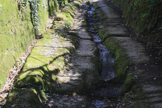
The Vie Cave (in English excavated roads), also known in Italian as Cavoni, is a road network in southern Europe, found in Spain, Italy, Turkey and as far east as Jordan. In Italy they partly link an Etruscan necropolis and several settlements in the area between Sovana, Sorano and Pitigliano. They consist mainly of trenches of variable width and length, excavated as nearly vertical cliffs in different types of bedrock, sometimes over sixty feet high, possibly serving as a defense system against invaders, wild animals or forces of nature. Although often dated as being carved by pre-Roman civilisations in the first or second millennium BC, the builders and purpose of the road system are largely unclear, and there are indications that they are much older than assumed.
In Italy they are sometimes narrow, sometimes wider cuttings often running deeply through hills and bedrock, and are thought to have changed little since Etruscan times. Their construction is said to have resulted from the wearing through soft tuff but also harder bedrock by iron-rimmed wheels, creating deep ruts that required the road to be frequently recut to a smooth surface. Their dating is mainly deduced from the settlements they pass between, and objects from tombs beside them. This dating is deemed uncertain by those pointing out the extent of petrifaction of the so-called cart ruts.
In Roman times segments of the Vie Cave became part of a road system that was connected to the main trunk of the Via Clodia, an ancient road linking Rome and Manciano, through the city of Tuscania, which branched off from the Cassia road in Lazio territory. Wider segments are even included in the modern road system.
Vie Cave of Sovana
Around Sovana, the Vie Cave wind around and towards the archaeological area of that town, then reconnecting with those from Sorano and Pitigliano.
Vie Cave in Sorano
Around Sorano the Vie Cave begin coming out of the Porta dei Merli, and descending into the valley of the river Lente.
The Via Cava (singular for Vie Cave) of San Rocco was on the opposite side of the Sorano county, along the ruins of the church of San Rocco, religious building of the romanesque art that retains parts of the original wall of the via. Behind the ruins of the church there is a vast Etruscan necropolis with tombs hewn into the tuff.
Near Poggio San Rocco and Poggio Croce there are also numerous Etruscan tombs and a columbarium, which are as rock-cut cells arranged in several rows one above the other. From Middle Ages on these ancient tombs became a shelter for pigeons.
Vie Cave of Pitigliano
Around Pitigliano there are several Vie Cave, including the one directed towards the archaeological area of Sovana.
(Wikipedia)
Die Vie Cave (italienisch auch Cavoni) sind teils tief gegrabene Straßen in der heutigen Gegend zwischen Sovana, Sorano und Pitigliano in der Provinz Grosseto in der Toskana. Sie bestehen hauptsächlich aus Gräben unterschiedlicher Breite und Länge, die als fast senkrechte Schluchten in verschiedene Arten von Grundgestein gegraben wurden, manchmal über 20 Meter tief, und möglicherweise als Verteidigungssystem gegen Eindringlinge, wilde Tiere oder Naturgewalten dienten.
Obwohl oft angenommen wird, dass sie von vorrömischen Zivilisationen im 1. oder 2. Jahrtausend v. Chr. angelegt wurden, sind die Erbauer und der Zweck des Straßensystems weitgehend unklar, und es gibt Hinweise darauf, dass sie viel älter sind als angenommen. Solche Straßennetze sind auch anderorts in Südeuropa, in Spanien, der Türkei und im Osten bis nach Jordanien bekannt.
In Italien sind sie manchmal schmale, manchmal breitere Einschnitte, die oft tief durch Hügel und Grundgestein verlaufen, und es wird angenommen, dass sie sich seit der Zeit der Etrusker kaum verändert haben. Sie sollen entstanden sein durch das Einwirken eisenbeschlagener Räder auf den weichen Tuffstein, aber auch auf härteres Grundgestein, deren tiefe Spurrillen es erforderlich machten, die Straße immer wieder auf eine ebene Oberfläche zu schleifen. Ihre Datierung leitet sich hauptsächlich aus den Siedlungen ab, zwischen denen sie hindurchgehen, und Gegenständen aus Gräbern neben ihnen. Diese Datierung wird von denjenigen als unsicher angesehen, die auf das Ausmaß der Versteinerung der sogenannten Karrenspuren hinweisen.
In der Römerzeit wurden Teile der Via Cave Teil des Straßensystems, das mit der Hauptstraße der Via Clodia verbunden war, einer alten Straße, die Rom und Manciano durch die Stadt Tuscania verband, die von der Cassia-Straße im Gebiet von Latium abzweigte. Breitere Abschnitte sind sogar im modernen Straßensystem enthalten.
(Wikipedia)