Observation Point
View Back
Rückblick
Zion National Park is located in the Southwestern United States, near Springdale, Utah. A prominent feature of the 229-square-mile (590 km2) park is Zion Canyon, which is 15 miles (24 km) long and up to half a mile (800 m) deep, cut through the reddish and tan-colored Navajo Sandstone by the North Fork of the Virgin River. The lowest elevation is 3,666 ft (1,117 m) at Coalpits Wash and the highest elevation is 8,726 ft (2,660 m) at Horse Ranch Mountain. Located at the junction of the Colorado Plateau, Great Basin, and Mojave Desert regions, the park's unique geography and variety of life zones allow for unusual plant and animal diversity. Numerous plant species as well as 289 species of birds, 75 mammals (including 19 species of bat), and 32 reptiles inhabit the park's four life zones: desert, riparian, woodland, and coniferous forest. Zion National Park includes mountains, canyons, buttes, mesas, monoliths, rivers, slot canyons, and natural arches.
Human habitation of the area started about 8,000 years ago with small family groups of Native Americans; the semi-nomadic Basketmaker Anasazi (300 CE) stem from one of these groups. In turn, the Virgin Anasazi culture (500 CE) developed as the Basketmakers settled in permanent communities. A different group, the Parowan Fremont, lived in the area as well. Both groups moved away by 1300 and were replaced by the Parrusits and several other Southern Paiute subtribes. Mormons came into the area in 1858 and settled there in the early 1860s. In 1909 the President of the United States, William Howard Taft, named the area a National Monument to protect the canyon, under the name of Mukuntuweap National Monument. In 1918, however, the acting director of the newly created National Park Service changed the park's name to Zion, the name used by the Mormons. According to historian Hal Rothman: "The name change played to a prevalent bias of the time. Many believed that Spanish and Indian names would deter visitors who, if they could not pronounce the name of a place, might not bother to visit it. The new name, Zion, had greater appeal to an ethnocentric audience." The United States Congress established the monument as a National Park on November 19, 1919. The Kolob section was proclaimed a separate Zion National Monument in 1937, but was incorporated into the park in 1956.
The geology of the Zion and Kolob canyons area includes nine formations that together represent 150 million years of mostly Mesozoic-aged sedimentation. At various periods in that time warm, shallow seas, streams, ponds and lakes, vast deserts, and dry near-shore environments covered the area. Uplift associated with the creation of the Colorado Plateaus lifted the region 10,000 feet (3,000 m) starting 13 million years ago.
(Wikipedia)
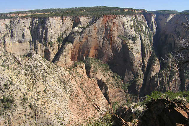
Observation Point is a 6,507-foot (1,983 m) elevation Navajo Sandstone feature located in Zion National Park, in Washington County of southwest Utah, United States. Observation Point is situated at the north end of Zion Canyon, towering 2,100 feet (640 meters) above the canyon floor and the North Fork of the Virgin River which drains precipitation runoff from this viewpoint. A popular 8-mile round-trip trail climbs from the Weeping Rock trailhead along Zion Canyon Road to reach the top. Neighbors visible from the point include The Great White Throne, Cathedral Mountain, Angels Landing, and Cable Mountain. This geographical feature's name was officially adopted in 1934 by the U.S. Board on Geographic Names.
Climate
Spring and fall are the most favorable seasons to visit Observation Point. According to the Köppen climate classification system, it is located in a Cold semi-arid climate zone, which is defined by the coldest month having an average mean temperature below 32 °F (0 °C), and at least 50% of the total annual precipitation being received during the spring and summer. This desert climate receives less than 10 inches (250 millimeters) of annual rainfall, and snowfall is generally light during the winter.
(Wikipedia)
Der Zion-Nationalpark befindet sich im Südwesten Utahs an der Grenze zu Arizona. Er hat eine Fläche von 579 km² und liegt zwischen 1128 m (Coalpits Wash) und 2660 m Höhe (Horse Ranch Mountain). 1909 wurde das Gebiet des Canyons zum Mukuntuweap National Monument ernannt, seit 1919 besitzt es den Status eines Nationalparks. Der Park wurde 1937 um den Kolob Canyon erweitert.
Zion ist ein altes hebräisches Wort und bedeutet so viel wie Zufluchtsort oder Heiligtum, das oft von den mormonischen Siedlern in Utah benutzt wurde. Innerhalb des Parks befindet sich eine schluchtenreiche Landschaft mit zahlreichen Canyons, von denen der Zion Canyon und der Kolob Canyon die bekanntesten sind. Die Canyons sind aus 170 Millionen Jahre altem braunen bis orangeroten Sandstein der Navajo-Formation entstanden. Der Park liegt an der Grenze zwischen dem Colorado-Plateau, dem Great Basin und der Mojave-Wüste. Durch seine besondere geografische Lage existiert im Park eine Vielzahl an unterschiedlichen Lebensräumen mit vielen verschiedenen Pflanzen und Tieren.
(Wikipedia)