"Oriented north-south, the monument is approximately 12 m long, the corridor 7 m long with a height at the entrance of 1.4 m ; the polygonal chamber has a height of 2.5 m ." Wiki
The Table des Marchand is a massive passage tomb with carved surface details that is situated around 2 hours walk east from the Neolithic stone rows of the Carnac megasite and 3km from the decorated corridor of the Gavrinis Neolithic cairn.
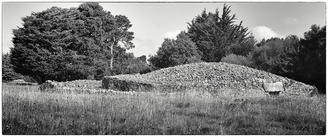
The Table des Marchand cairn's interior megalithic 'dolmen' is well known from ancient postcards. A massive slab 'floating' on three orthostats. It was covered with the above cairn around 1991.
Much of the cairn's drystone work is 'crossed' and there are no 'stacks of plates' - an effect in some Neolithic walls where flat stones are stacked as adjacent 'towers'. Patches of uncrossed stones can be seen into the iron age.
The vestiges of the cairn's curb-stone perimeter will have been analysed during excavations in 1883, 1937, 1985 and 1991, so the dimensions of the outer cairn will have been based on observation.
The infill stones that make the cairn's dome are 'sharp' as if quarried with modern machine rather than collected rounded granite softened by time and elements - so common in these shores. Today the cairn's top surface is uniformly accidented and not made for social use - a simple silhouette without possible function beyond that of covering the megalith: a uniform texture for form alone. Here, persons running to the top might sprain ankles or trip. A drizzle of immediately available beach gravel, selected vegetation and even powders or 'tere battue' sands would have issued the mound's summet a gravitas and sense of arresting loci: a meaningful and decided place just above those below.
Alas, the sands of time can take small stones away.
After my 2022 posts analysing the Neolithic earthworks known as Causewayed Enclosures (titled: 'Pedestal circles' for gathered late period 'Transport Dragons' 3700-3625 BC), I will continue to argue that the artificial pinacle was an important theme in the Neolithic, and that the cairn was another example of a structure that offered a pedestal for living iconographies. The subject of what went on each pedestal, and why, will be addressed in associated posts.
A secure chamber under a pinacle would be for storage for the clan network responsible for the construction. Food does not benefit from being on a domed pedestal or from being inside such heavily symbolic megaliths, and the storage would here be for culturally important items.
A pinacle with multiple storage (Barnenez, Petit Mont and to an extent Les Pierres Plates and West Kennet) would work for a pedestal earthwork that was dedicated to groups of clans. Pedastles made for winners of games from an array of clan groups, or for the worshiping general seasonal Gods, generalizable life moments and events would not benefit from the appropreation issues that megalithic storage 'tunnels' issued, and might therefore appear as an artificial hill alone to a horizon. Here Marlborough Mound (19m heigh) and Silbury Hill (30m heigh) are vivid examples aside many long-barrows of the category "unchambered" barrows". Further afield, Mastabas are later but show similar functional combinations, even if the locked storage is more focussed on the symbolic idea of individuals.
With my hypothesis of 'storage under pedestal', it might be said that in retrospect the act of concentrating on the megalith took the mind from the dynamic function of the spaces between and above.
Saying that the interior megalith was simply 'covered' was like saying that a pedastle for a statue is just a cover for a square on the floor.
A 'cairn' is today a waypoint, a marker: a stage is a 'pedastle' for the actors who climb into their theatre. The stage does not function as a 'waypoint' to tell the audience that they are in a theatre, the stage is there for specific and organised effect.
With this hypothesis of man-made combined storage and pinnacle, an authority from 'history' who was interested in the centralisation of rural areas might have quietly and easily removed the 'power' from the vestiges from deep history and tradition by taking down the pedastle and exposing the inevitable gaps and openings between the megaliths, thus with one gest flattening the gravitas of the loci and diminish the idea of permanent and even illusive secure storage. The landscape of largely skeletal megaliths may help explain why cairns and tumuli are amiss from many sites.
With modesty, I renamed the Neolithic earthworks known as 'Causwayed Enclosures' to 'Pinacle circles' to switch the emphasis from the 'Causeway' gaps to the circle of long pedastles, and for the wide range of Neolithic and at times bronze age tumuli, barrows, cairns and arificial hills, I will use the group term 'Artificial Pedastle landmarks' - an admittedly dull term, but one that leaves a place for 'natural pedastle landmarks'.
As the dead bodies of households were regularly (but not exclusively) burried under floors of Neolithic houses, with time, persons implicated in the articicial pedestal landmark might be burried/stored/remembered within the megalithic storage under the pedastle or within the earthwork. Obviously with time, the burrial theme might at times take over the deffinition of the storage tunnel.
The village of Carnac sits at the head of the protected Quiberon bay with its tidal dimensions breathing 10km average tangents. The Table des Marchand is found between many other megalithic giants aside the village of Locmariaquer towards the entrance to Carnac's bay. Locmariaquer is from a wizzoned head strong isimut between the breezy iodine of the Quiberon bay and the brackish corrugated currents of the bay of Morbian. In land from the coast, surface-water holds above the granitic landscape, giving the smallest streams winter significance, and this world was a wide vista dedicated to the rise and fall of water.
The Table des Marchand was constructed between 3900 and 3800 BC. The Carnac alignments (around 9km north west) are thought to date between 3300 BC and 4500 BC, so this great dolmen was perhaps made 500 years after the start and perhaps 700 years before the end of main alignment activity.
One detail remains central to the 'Table des Marchand' and it resolves around a massive 15m long megalith that had been carved with petroglyphs and then broke in three. More likely a recumbant entrance stone than the oft muted menhir. With an act that communicates Neolithic seafaring, Neolithic skills of coordination and Neolithic transportation prowess, portions of the once unified and carved many-multi-tonne megalith were distributed between three giant dolmens (Allée couverte). Two parts on the south west of the opening between the bay of Morbihan and the Quiberon Atlantic, with the last broken third covering the decorated corridor of the cairn on the island of Gavrinis (pictured in an adjacent post). Gavrinis is five kilometres away over water, detouring the Ile Longue.
"It is a part of a broken tabular block, of which another part was transported by sea over the Gavrinis cairn, about 5 kilometers away (the horns and backbone of the bovine are found on the covering slab), and another one, in the Er Grah burial mound, located a few meters from the Table des Marchands; the decorative motifs complement each other perfectly." Wiki
How did the massive carved stone break so that the carving of the Ox became distributed between three key sites? Impossible to say, but around 4700BC, aside Locmaraquier, was built a super massive standing stone: 330 tonnes and over 20m high. This fell with some force around 4000 BC or earlier: did it break an adjacent carved stone as it fell? Alternatively, was there a mood to move the carved stone which went wrong causing it to slide and crash and break? Once broken, did the participants each take a part to share responsibility and assure cohesion?
AJM 22.01.23.
AJM 10.03.23