Phnom Chisor (Khmer: ភ្នំជីសូរ, Phnum Chisor [pʰnom ciːsoː]; "Chisor Mountain") is a 133-metres high mountain in Dok Por village, Rovieng commune, Samraŏng District, Takéo Province, Cambodia. It lies about 42 km south of Phnom Penh. The Ministry of Culture and Fine Art are preparing documents to nominate the site in the list of UNESCO world heritage.
Temple: Prasat Phnom Chisor
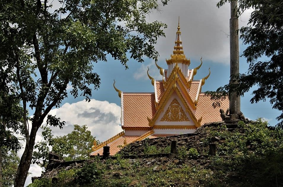
There is an ancient Khmer temple, Prasat Phnom Chisor (Khmer: ប្រាសាទភ្នំជីសូរ) (or Phnom Chisor Temple, sometimes referred to just Phnom Chisor) located on top of the hill. The temple was built in the 11th century of laterite and bricks with carved sandstone lintels by the Khmer Empire king Suryavarman I, who practiced Brahmanism. It was dedicated to the Hindu divinities Shiva and Vishnu. The original name of the temple was Sri Suryaparvata (Khmer: សុរ្យបវ៌ត), or The Mountain of Surya[varman] (The mountain of the Sun).
On the east edge of the mountain, at the back of the temple, there is a prime spot for view and pictures where you can see a vast plain of surrounding rice fields and countryside. From there, looking down to the east can see an avenue that forms a straight line connecting three main features including two outer gates (temples) of cruciform ground plan and a baray:
Sen Nimol Temple (Khmer: ប្រាសាទសែននិមល(?)): now heavily grown, situated just below the mountain;
Sen Roveang Temple (Khmer: ប្រាសាទសែនរវាំង or សែនភូវាំង): a stately building now used as a Buddhist sanctuary about 800m from Sen Nimol Temple;
Tonle Om (Khmer: ទន្លេអុំ): the ancient baray of Phnom Chisor Temple.
The Khmer Empire was a Hindu-Buddhist empire in Southeast Asia, centered around hydraulic cities in what is now northern Cambodia. Known as Kambuja by its inhabitants, it grew out of the former civilisation of Chenla and lasted from 802 to 1431. Historians call this period of Cambodian history the Angkor period, after the empire's most well-known capital, Angkor. The Khmer Empire ruled or vassalised most of mainland Southeast Asia and stretched as far north as southern China. At its peak, the Empire was larger than the Byzantine Empire, which existed around the same time.
The beginning of the Khmer Empire is conventionally dated to 802, when Khmer prince Jayavarman II declared himself chakravartin (lit. 'universal ruler', a title equivalent to 'emperor') in the Phnom Kulen mountains. Although the end of the Khmer Empire has traditionally been marked with the Fall of Angkor to the Siamese Ayutthaya Kingdom in 1431, the reasons for the empire's collapse are still debated amongst scholars. Researchers have determined that a period of strong monsoon rains was followed by a severe drought in the region, which caused damage to the empire's hydraulic infrastructure. Variability between droughts and flooding was also a problem, which may have caused residents to migrate southward and away from the empire's major cities.
The site of Angkor is perhaps the empire's most notable legacy, as it was the capital during the empire's zenith. The majestic monuments of Angkor, such as Angkor Wat and Bayon, bear testimony to the Khmer Empire's immense power and wealth, impressive art and culture, architectural technique, aesthetic achievements, and variety of belief systems that it patronised over time. Satellite imaging has revealed that Angkor, during its peak in the 11th to the 13th centuries, was the most extensive pre-industrial urban complex in the world. Researchers have also concluded that the Khmer Empire invented the world's first healthcare system, which included 102 hospitals.
Etymology
Modern scholars often refer to the empire as the "Khmer Empire" (Khmer: ចក្រភពខ្មែរ) or the "Angkor Empire" (Khmer: ចក្រភពអង្គរ), the latter after the capital Angkor.
The empire referred to itself as Kambuja (Sanskrit: កម្ពុជ; Old Khmer: កម្វុជ; Khmer: កម្ពុជ) or Kambujadeśa (Sanskrit: កម្ពុជទេស, lit. 'country of Kambuja'; Old Khmer: កម្វុជទេឝ; Khmer: កម្ពុជទេស), names which were pre-modern predecessors to the modern Kampuchea.
Historiography
No written records of the Angkor period have survived other than stone inscriptions. Current knowledge of the historical Khmer civilisation is derived primarily from:
Archaeological excavation, reconstruction and investigation
Stone inscriptions (the most important of which are foundation steles of temples), which report on the political and religious deeds of the kings
Reliefs in a series of temple walls with depictions of daily life, market scenes, military marches, and palace life
Reports and chronicles of Chinese diplomats, traders, and travellers
According to an inscription in the Sdok Kok Thom temple, around 781 the Khmer prince Jayavarman II established Indrapura as the capital of his domain. It was located in Banteay Prey Nokor, near today's Kampong Cham. After returning to his home in the former kingdom of Chenla, he quickly built up his influence and defeated a series of competing kings. In 790 he became king of a kingdom called Kambuja by the Khmer. He then moved his court northwest to Mahendraparvata, far inland north from the great lake of Tonlé Sap.
Jayavarman II (reigned 802–835) is widely regarded as the king who set the foundations of the Angkor period. Historians generally agree that this period of Cambodian history began in 802, when Jayavarman II conducted a grandiose consecration ritual on the sacred Mount Mahendraparvata, now known as Phnom Kulen. At the ritual, which was taken from the Hindu tradition, Jayavarman II proclaimed himself as chakravartin (from Sanskrit, lit. 'universal ruler'; Old Khmer: Kamraten jagad ta Raja) and devaraja (from Sanskrit, lit. 'god king'). He also declared Kambuja's independence from a place inscriptions call "Java".
Historians debate whether "Java" means the Indonesian island of Java, Champa or a different location. According to an older established interpretation, Jayavarman II was a prince who lived at the court of Sailendra in Java and brought back to Cambodia the art and culture of the Javanese Sailendran court (such as the concept of a devaraja). This classical theory was criticized by modern scholars such as Claude Jacques and Michael Vickery, who noted that the Khmer used the term chvea to describe the Chams, their neighbours to the east. But in 2013 Arlo Griffiths refuted these theories and convincingly demonstrated that in almost all cases the inscriptions mention Java they refer to the island of Java in the Indonesian archipelago.
Jayavarman's political career began in Vyadhapura (likely the modern-day ruins of Banteay Prey Nokor) in eastern Cambodia. Moreover, many early temples on Phnom Kulen show Cham (e.g. Prasat Damrei Krap) as well as Javanese influences (e.g. the primitive "temple-mountain" of Aram Rong Cen and Prasat Thmar Dap), even if their asymmetric distribution seems typically Khmer.
In the following years, Jayavarman II extended his territory and established a new capital, Hariharalaya, near the modern-day town of Roluos. He thereby laid the foundation of Angkor, which was to arise some 15 kilometres (9.3 mi) to the northwest. Jayavarman II died in 835 and was succeeded by his son Jayavarman III. Jayavarman III died in 877 and was succeeded by Indravarman I.
The successors of Jayavarman II kept extending the territory of Kambuja. Indravarman I (reigned 877–889) managed to expand the kingdom without wars and initiated extensive building projects, which were enabled by the wealth gained through trade and agriculture. Foremost were the temple of Preah Ko and irrigation works. Indravarman I developed Hariharalaya further by constructing Bakong. Bakong in particular bears striking similarities to the Borobudur temple in Java, which suggests that it may have served as the prototype for Bakong. There were at the time exchanges of travellers and missions between Kambuja and the Sailendras in Java, which brought to Cambodia not only ideas, but also technical and architectural details.
Indravarman I was followed by his son Yasovarman I (reigned 889–915), who established a new capital, Yasodharapura – the first city of the larger Angkor area. The city's central temple was built on Phnom Bakheng, a hill which rises around 60 m above the plain on which Angkor sits. The East Baray, a massive water reservoir measuring 7.1 by 1.7 kilometres (4.4 by 1.1 mi), was also created under the reign of Yasovarman I.
At the beginning of the 10th century, the empire fractured. Jayavarman IV moved the capital to Lingapura (now known as Koh Ker), some 100 kilometres (62 mi) northeast of Angkor. Only when Rajendravarman II ascended to the throne (reigned 944–968) was the royal palace returned to Yasodharapura. He once again took up the extensive building schemes of the earlier kings and established a series of Hindu temples in the Angkor area, such as Pre Rup and the East Mebon, a temple located on an artificial island in the center of the East Baray. Several Buddhist temples and monasteries were also built. In 950, the first war took place between Kambuja and the kingdom of Champa to the east (in what is now central Vietnam).
The son of Rajendravarman II, Jayavarman V, reigned from 968 to 1001, after establishing himself as the new king over the other princes. His rule was a largely peaceful period, marked by prosperity and a cultural flowering. He established a new capital slightly west of his father's and named it Jayendranagari; its state temple, Ta Keo, was to the south. At the court of Jayavarman V lived philosophers, scholars, and artists. New temples were also established; the most important of these were Banteay Srei, considered one of the most beautiful and artistic of Angkor, and Ta Keo, the first temple of Angkor built completely of sandstone.
A decade of conflict followed the death of Jayavarman V. Three kings reigned simultaneously as antagonists to each other until Suryavarman I (reigned 1006–1050) ascended to the throne by taking the capital Angkor. His rule was marked by repeated attempts by his opponents to overthrow him and military conflicts with neighbouring kingdoms. Suryavarman I established diplomatic relations with the Chola dynasty of south India early in his rule.
In the first decade of the 11th century, Kambuja came into conflict with the kingdom of Tambralinga in the Malay peninsula. After surviving several invasions from his enemies, Suryavarman requested aid from the powerful Chola emperor Rajendra I against Tambralinga. After learning of Suryavarman's alliance with Chola, Tambralinga requested aid from the Srivijaya king Sangrama Vijayatungavarman. This eventually led to Chola coming into conflict with Srivijaya. The war ended with a victory for Chola and Kambuja, and major losses for Srivijaya and Tambralinga. The two alliances had religious nuance, as Chola and Kambuja were Hindu Shaivite, while Tambralinga and Srivijaya were Mahayana Buddhist. There is some indication that, before or after the war, Suryavarman I gifted a chariot to Rajendra I to possibly facilitate trade or an alliance.
Suryavarman I's wife was Viralakshmi, and following his death in 1050, he was succeeded by Udayadityavarman II, who built the Baphuon and West Baray. In 1074, conflict arose between Harshavarman III, the younger brother and successor of Udayadityavarman II, and the Champa king Harivarman IV.