Rhuddlan Castle is a castle located in Rhuddlan, Denbighshire, Wales. It was erected by Edward I in 1277, following the First Welsh War.
Much of the work was overseen by master mason James of Saint George. Rhuddlan, which was not completed until 1282, was built concurrently with Flint Castle, at a time when King Edward I of England was consolidating his conquest of Wales. It was temporarily his residence, and his daughter, Elizabeth, is presumed to have been born there.
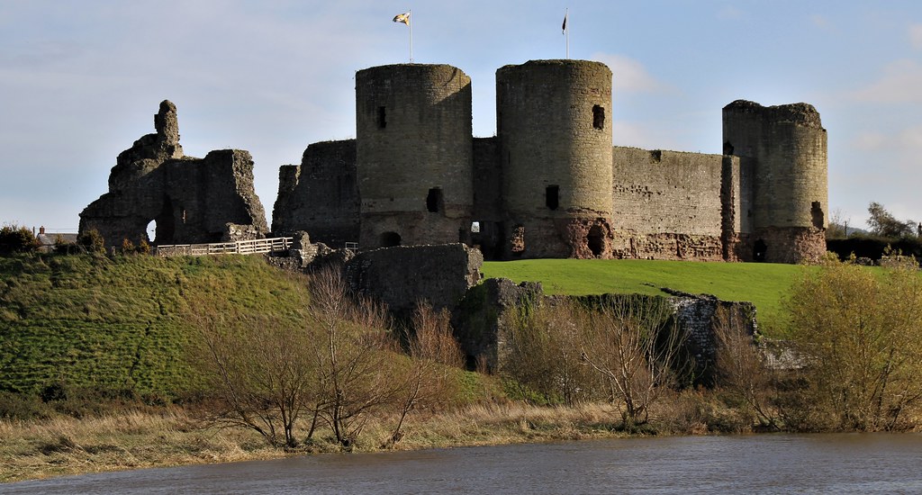
Rhuddlan was planned as a concentric castle. It has a unique 'diamond' in layout as the gatehouses are positioned at the corners of the square baileys instead of along the sides like at Flint, Harlech or Beaumaris. Records of construction costs show that it was the major piece of building work being carried out by the English during the late 1270s.
The inner ward has defensive walls with twin-tower gatehouses. The outer ward is surrounded by a curtain wall that has small towers and turrets. According to Thomas Pennant, who passed through the town on his travels in the 18th century, one of the towers is named "Twr-y-Silod" ("Grain Tower"), and another "Twr-y-Brenin" ("The King's Tower"). The castle had a three-sided moat, with the River Clwyd protecting its fourth side. Within the inner ward there was a great hall, kitchens, private apartments and a chapel. The outer bailey had a granary, stables and a smithy.
Rhuddlan is next to the River Clwyd. During the fortification's lengthy construction, the river course was straightened and dredged to allow ships to sail inland along a man-made channel. Its purpose was to allow provisions and troops to reach the castle even if hostile forces or a siege prevented overland travel.
A further protective earthwork and timber structure was created around it in 1280–82. The castle was completed prior to the rebellion of Llywelyn the Last in 1282.
The story of Rhuddlan goes back much further than the fortress built by Edward I. Prior to the Norman occupation of lower Gwynedd, Rhuddlan was at the heart of a Welsh cantref. From here the Lords of Rhuddlan commanded the Perfeddwlad (lands of north-east Wales) on behalf of Gruffydd ap Llywelyn (1007 – 5 August 1063), the last ruler of all Wales. The town itself, however, began as a Saxon "burgh" founded by Edward the Elder.
In the late 11th century, the Normans invaded Gwynedd. Rhuddlan's strategic position ensured that it was fought over by the Princes of Gwynedd and the Earls of Chester, with Gruffydd ap Llywelyn, who had been driven out by Harold Godwinson, re-taking the town. The remains of a Norman castle at Twthill, built in 1086, is just to the south of the current castle; it was built by Robert of Rhuddlan, a supporter of King William I of England.
In July 1277, at the outbreak of the Welsh Wars, Edward I left Chester and established an advance base at Flint, where building work immediately began on Flint Castle. With naval assistance from 25 ships of the Cinque Ports fleet, the army pushed along the coast. By August Edward had moved his forces on to Rhuddlan, which, as was his custom, he was able to supply by river. Three months later the town was ceded to the English Crown following the Treaty of Aberconwy between Llywelyn ap Gruffudd and Edward I.
Work on Rhuddlan Castle began immediately under the control of Master Bertram, a Gascon engineer, but construction was soon handed over to Savoyard master mason, James of St George, who remained in charge until labour ceased in 1282. Besieged by the Welsh during the rebellion of 1282, until relieved by an English force led by future Amadeus V, Count of Savoy.
Edward I also created a new borough, north of his castle, away from the pre-existing Norman town and Dominican Friary. The 13th-century street layout can still be seen in the modern town. The borough, like at Flint, was defended with a pair of ditch-separated earthworks and a timber palisade. Rhuddlan Castle became a part of Edward's Ring of Iron fortifications.
Elizabeth, the eighth daughter of Edward I, was born at Rhuddlan in 1282, the same year work at the castle was completed. Two years later the Statute of Rhuddlan was signed at the castle following the defeat of Llewellyn the Last, who had attacked the castle unsuccessfully. It ceded all the lands of the former Welsh Princes to the English Crown and introduced English common law. Edward I could now appoint Royal officials such as sheriffs, constables and bailiffs to collect taxes and enforce English law throughout Wales. Following Rhuddlan, the counties of north western North Wales were placed under the control of the Justiciar of North Wales. Although the statute brought in English legislation, Welsh law continued to be practised at local level after the conquest of the Wales. This remained the case until 1536 when Rhuddlan's statute was repealed by the Laws in Wales Acts 1535 and 1542 that made English common law the exclusive judicial system in Wales.
In 1294 the castle was attacked during the Welsh rising of Madog ap Llywelyn but was not taken. It remained in English hands and was one of the places where King Richard II of England stopped in 1399 on his way to Flint, where he would be taken prisoner by his rival, Henry IV. It was attacked again in the following year by forces of Owain Glyndŵr in 1400. This time the town was badly damaged but the castle held out. In the latter 15th and early 16th centuries the castle's condition deteriorated as its strategic and administrative importance waned.
Rhuddlan Castle was again garrisoned by Royalist troops during the English Civil War, and remained a stronghold of King Charles I of England until well after the Battle of Naseby, being taken by Parliamentary forces under Thomas Mytton after a siege in 1646. Two years later, Parliamentarians partially demolished the castle to prevent any further military use. By the time Pennant passed through in 1781, it was largely ruined.
Rhuddlan is a town, community, and electoral ward in the county of Denbighshire, Wales, in the historic county of Flintshire. Its associated urban zone is mainly on the right bank of the Clwyd; it is directly south of seafront town Rhyl. It gave its name to the Welsh district of Rhuddlan from 1974 to 1996. As of the 2001 census, the population was 4,296 decreasing to 3,709 in the 2011 census.
The name of the town is a combination of the Welsh words rhudd "red" + glan "riverbank".
In AD 921, the Anglo-Saxon king, Edward the Elder, founded a burh named Cledematha (mouth of the Clwydd) at Rhuddlan. In the following century, before the Norman Conquest and subsequent Norman occupation of lower Gwynedd, the Perfeddwlad, Rhuddlan was the site of a Welsh cantref and served as the seat of government and capital of Gwynedd for the Welsh king Gruffydd ap Llywelyn (ruled 1055–1063). Following the Conquest, in 1086, Rhuddlan was recorded in the Domesday Book as a small settlement within the hundred of Ati's Cross and in the county of Cheshire.
A mint established at Rhuddlan in the 1180s by Dafydd ab Owain, and later maintained by Llywelyn the Great, was responsible for minting the first native Welsh coinage since the reign of Hywel Dda.
The town is known for the ruins of Rhuddlan Castle, built by order of King Edward I from 1277 to 1282, and for the site of another castle at Twthill, built by the Norman Robert of Rhuddlan about 1072. Well-preserved Rhuddlan castle has a great round tower and many surviving walls. It was built soon after the conquest of Wales.
The town was thus where Edward I signed the Statute of Rhuddlan, laying down the way by which the Principality of Wales, created by the princes of Gwynedd, was to be governed.
The town's first Welsh chapel, now 17 Cross Street, was built in 1771.
The hymn tune "Rhuddlan" was brought to wider prominence by Ralph Vaughan Williams as music editor of the first edition of The English Hymnal in 1906, and it has since been adopted by numerous other hymnals. It is usually sung to the words of the hymns "Judge eternal, throned in splendour" and, more recently, "For the healing of the nations".
Rhuddlan railway station was part of the Vale of Clwyd Railway. The station closed in 1955 but the line remained open until 1968. The station was demolished around 1977 and a Premier Inn hotel now occupies the site.
In 2001, the A525 bypass was completed, easing access to Rhyl. Since 2001 the centre of Rhuddlan has been largely redeveloped.
In 2021 February, archaeologists from Aeon Archaeology announced the discovery of more than 300 stone age tools and artefacts in Rhuddlan. They revealed scrapers, microliths, flakes of chert (hard, sedimentary rock), flints and even rudimentary tools. Expert Richard Cooke believes that the remains were belong to people who was passing through and made camp by the river more than 9,000 years ago.
Notable people
See Category:People from Rhuddlan
Hugh of Rhuddlan an important Cambro-Norman poet writing in Old French at the end of the 12th century.
Philip Jones Griffiths (1936–2008), photographer particularly of the Vietnam War, and a member of Magnum Photos.
Lisa Scott-Lee (born 1975) of the pop band Steps and her brother Andy Scott-Lee (born 1980) lived in Rhuddlan.
Peter Smith (born 1978) footballer with 180 club caps
David Vaughan (born 1983) footballer with 476 club caps and 42 for Wales
Kelly Lee Owens (born 1988), electronic musician and producer; grew up in a nearby village.
Jack Sargeant (born 1994) politician, and a Member of the Senedd (MS).
Denbighshire is a county in the north-east of Wales. It borders the Irish Sea to the north, Flintshire to the east, Wrexham to the southeast, Powys to the south, and Gwynedd and Conwy to the west. Rhyl is the largest town, and Ruthin is the administrative centre. Its borders differ from the historic county of the same name.
Denbighshire has an area of 326 square miles (840 km2) and a population of 95,800, making it sparsely populated. The most populous area is the coast, where Rhyl (25,149) and Prestatyn (19,085) form a single built-up area with a population of 46,267. The next-largest towns are Denbigh (8,986), Ruthin (5,461), and Rhuddlan (3,709). St Asaph (3,355) is a city. All of these settlements are in the northern half of the county; the south is even less densely populated, and the only towns are Corwen (2,325) and Llangollen (3,658).
The geography of Denbighshire is defined by the broad valley of the River Clwyd, which is surrounded by rolling hills on all sides except the north, where it reaches the coast. The Vale of Clwyd, the lower valley, is given over to crops, while cattle and sheep graze the uplands. The Clwydian Range in the east is part of the Clwydian Range and Dee Valley Area of Outstanding Natural Beauty.
This part of Wales contains the country's oldest known evidence of habitation – Pontnewydd (Bontnewydd-Llanelwy) Palaeolithic site has Neanderthal remains of some 225,000 years ago. The county is also home to several medieval castles, including Castell Dinas Brân, Denbigh, and Rhuddlan, as well as St Asaph Cathedral. Llangollen International Musical Eisteddfod takes place in the town each July.
The main area was formed on 1 April 1996 under the Local Government (Wales) Act 1994, from various parts of the county of Clwyd. It includes the district of Rhuddlan (formed in 1974 entirely from Flintshire), the communities of Trefnant and Cefn Meiriadog from the district of Colwyn (entirely Denbighshire) and most of the Glyndŵr district. The last includes the former Edeyrnion Rural District, part of the administrative county of Merionethshire before 1974, covering the parishes of Betws Gwerfil Goch, Corwen, Gwyddelwern, Llangar, Llandrillo yn Edeirnion and Llansanffraid.
Other principal areas including part of historical Denbighshire are Conwy, which picked up the remainder of 1974–1996 Colwyn, the Denbighshire parts of 1974–1996 Aberconwy, and Wrexham, which corresponds to the pre-1974 borough of Wrexham along with most of Wrexham Rural District and several parishes of Glyndŵr. Post-1996 Powys includes the historically Denbighshire parishes of Llanrhaeadr-ym-Mochnant, Llansilin and Llangedwyn, which formed part of Glyndŵr district.
Researchers have found signs that Denbighshire was inhabited at least 225,000 years ago. Bontnewydd Palaeolithic site is one of the most significant in Britain. Hominid remains of probable Neanderthals have been found, along with stone tools from the later Middle Pleistocene.
In 2021 February, archaeologists from Aeon Archaeology announced a discovery of over 300 Stone Age tools and artifacts in Rhuddlan. They revealed scrapers, microliths, flakes of chert (a hard, fine-grained, sedimentary rock composed of microcrystalline or cryptocrystalline quartz), flints and other rudimentary tools. An expert, Richard Cooke, believes the lithic remains belonged to ancient peoples, who while passing through the area, made camp by the river more than 9,000 years ago.
The eastern edge of Denbighshire follows the ridge of the Clwydian Range, with a steep escarpment to the west and a high point at Moel Famau (1,820 ft (555 m)), which with the upper Dee Valley forms an Area of Outstanding Natural Beauty, the Clwydian Range and Dee Valley – one of just five in the Wales. The Denbigh Moors (Mynydd Hiraethog) are in the west of the county and the Berwyn Range adjacent to the southern edge. The River Clwyd has a broad fertile Vale running from south–north in the centre of the county. There is a narrow coastal plain in the north which much residential and holiday-trade development. The highest point in the historic county was Cadair Berwyn at 832 m or 2,730 ft), but the boundary changes since 1974 make Cadair Berwyn North Top the highest point. Denbighshire borders the present-day principal areas of Gwynedd, Conwy County Borough, Flintshire, Wrexham County Borough, and Powys.
Rhyl and Prestatyn form a single built-up area in the north of the county, with a population of 46,267. They are immediately adjacent to the Kinmel Bay and Abergele built-up area in neighbouring Conwy, and at the eastern end of series of coastal resorts which that also includes Colwyn Bay and Llandudno further west.
According to the 2021 United Kingdom census, Denbighshire's population was approximately 95,800. According to previous censuses, the population of Denbighshire was 93,734 in 2011 and 93,065 in 2001. The largest towns on the coast are Rhyl (2001 population c. 25,000) and Prestatyn (2001 population c. 18,000). According to the 2011 Census returns, 24.6 per cent stated they could speak Welsh.
Since the 20th-century demise of the coal and steel industries in the Wrexham area, there is no heavy industry in the county. Although most towns have small industrial parks or estates for light industry, the economy is based on agriculture and tourism. Much of the working population is employed in the service sector. The uplands support sheep and beef cattle rearing, while in the Vale of Clwyd dairy farming and wheat and barley crops predominate. Many towns have livestock markets and farming supports farm machinery merchants, vets, feed merchants, contractors and other ancillaries. With their incomes on the decline, farmers have found opportunities in tourism, rural crafts, specialist food shops, farmers' markets and value-added food products.
The upland areas with their sheep farms and small, stone-walled fields are attractive to visitors. Redundant farm buildings are often converted into self-catering accommodation, while many farmhouses supply bed and breakfast. The travel trade began with the arrival of the coast railway in the mid-19th century, opening up the area to Merseyside. This led to a boom in seaside guest houses. More recently, caravan sites and holiday villages have thrived and ownership of holiday homes increased. Initiatives to boost the economy of North Wales continue, including redevelopment of the Rhyl seafront and funfair.
The North Wales Coast Line running from Crewe to Holyhead is served by Transport for Wales and Avanti West Coast services. Trains leaving Crewe to pass through Chester, cross the River Dee into Wales, and continue through Flint, Shotton, Holywell Junction (closed in 1966), Prestatyn, Rhyl, and stations to Bangor and Holyhead, which has a ferry service to Ireland.
There are no motorways in Denbighshire. The A55 dual carriageway runs from Chester through St Asaph to the North Wales coast at Abergele, then parallel to the railway through Conwy and Bangor to Holyhead. The A548 run from Chester to Abergele through Deeside and along the coast, before leaving the coast and terminating at Llanrwst. The main road from London, the A5, passes north-westwards through Llangollen, Corwen and Betws-y-Coed to join the A55 and terminate at Bangor. The A543 crosses the Denbigh Moors from south-east to north-west, and the A525 links Ruthin with St Asaph.
There are local bus services between the main towns. Several services by Arriva Buses Wales run along the main coast road between Chester and Holyhead, linking the coastal resorts. Another route links Rhyl to Denbigh.
Denbighshire is represented in the House of Commons by three MPs. The Welsh Labour Party lost to the Welsh Conservatives in the 2019 general election for the first time.
The following MPs were elected from Denbighshire in 2019:
Simon Baynes (Welsh Conservatives) in Clwyd South, first elected in 2019.
David Jones (Welsh Conservatives) in Clwyd West, first elected in 2005.
James Davies (Welsh Conservatives) in Vale of Clwyd, first elected in 2019.
Denbighshire is also represented in the Senedd by three members elected in 2021:
Ken Skates (Welsh Labour) in Clwyd South, first elected in 2011
Darren Millar (Welsh Conservatives) in Clwyd West, first elected in 2007
Gareth Davies (Welsh Conservatives) in Vale of Clwyd, first elected in 2021.
In 2019, research by UnHerd in association with the pollster FocalData showed that most people across the county support the British monarchy.