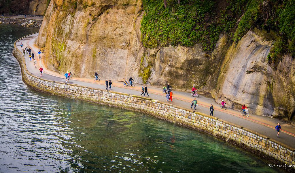
View of the Stanley Park seawall from the Siwash Rock viewpoint on New Years Day 2014.
The original idea for the seawall is attributed to park board superintendent, W. S. Rawlings, who conveyed his vision in 1918
Rawlings said:
“It is not difficult to imagine what the realization of such an undertaking would mean to the attractions of the park and personally I doubt if there exists anywhere on this continent such possibilities of a combined park and marine walk as we have in Stanley Park”.
The proposal was made to the federal government that it should help finance seawall construction because it owned the park and only leased the land to the city. It was argued that the waves created by ships passing through the First Narrows were eroding the area between Prospect Point and Brockton Point. On this basis, the federal government helped pay for the wall only until 1967 because the portions of the park vulnerable to erosion were now protected.
Most of the Stanley Park portion of the wall was built between 1917 and 1971, although the park portion was not completed until 1980. Much of the original wall was constructed under the direction of James "Jimmy" Cunningham, a master stonemason who spent 32 years on the project until his death. Cunningham continued supervising construction into his last days despite being ill, and on at least one occasion, went to check the seawall's progress still wearing pajamas. He died on September 29, 1963, long before the wall was finished, but remains the one most associated with the project, and a commemorative plaque can be found near Siwash Rock, also where his ashes were scattered. In contrast to the continuity during Cunningham's oversight of the project, construction of the seawall was intermittent, owing to the short-term funding commitments of the civic and federal governments. The first 4,000 feet was completed between 1914 and 1916. A series of storms threatened the foreshore near Second Beach during the war, when water flooded the patch of land between the beach and Lost Lagoon. In 1920, the wall served as aworkfare project for 2,300 unemployed men (the largest number of workers at any one time), and by 1939, 8,000 more feet of the wall was finished.[4] Another 9,100 feet was built between 1950 and 1957, and the final 2,500 feet was not taken on until 1968. On September 26, 1971, the last block, completing the original vision of the seawall, was tapped into place by H. H. Stevens, who also helped initiate the project in 1914 as a Member of Parliament for Vancouver. Others that laboured on the wall included unemployed relief workers again during the Great Depression and seamen from HMCS Discovery on Deadman's Island facing punishment detail in the 1950s. Also in that decade, stone sets from the recently dismantled BC Electric Railway streetcar system were incorporated into the seawall.
In 2010 and 2011, two portions of the Seawall, Stanley Park (near Second Beach) and English Bay (near Sunset Beach), were renewed to address ongoing concerns with erosion.
With deep foundations and renewed surfacing, the new Seawall is built to withstand the tides for many years to come.
The seawall route has continued to expand, so that a continuous, mostly seaside, path for pedestrians, cyclists, and inline skaters now extends for a total of 22 kilometres. Starting from Coal Harbour, it winds around Stanley Park, along Sunset Beach, around False Creek, past the Burrard Street Bridge, through Vanier Park, and finishes off at Kitsilano Beach Park.
The Stanley Park section of the seawall is 8.8 kilometres (5 miles) in length. The seawall is used by more than 2,500,000 people every year. Park visitors walk, bike, roll, and fish on the seawall.
.
.
Permission to Use photo.
.
18 Sep 2014
.
Vancouver-urgent stock request!
Hi Ted,
My name is Jessie Adler, I'm the photo editor at Hemispheres magazine, United's in-flight magazine. I found a photo of yours on Flickr and I would like to use it in the November issue of our magazine, in a story called Three Perfect Days: Vancouver. I am hoping that you will grant me permission to use it, and that you can send me the high res, unwatermarked image. We will credit you and can offer $50 for usage. Please let mek now if you can help! My work email is jessie.adler@ink-global.com and my number is 347.294.1206.
Thank you!
Jessie
.
.
Permission to use photo.
.
03 May 2016
Trans Canada Trail / Le sentier Transcanadien
Hi Ted,
I work with the Trans Canada Trail and we are putting together the May issue of our monthly e-newsletter, Trail Talk. This bulletin goes out to roughly 15,000 recipients made up of donors and TCT supporters.
I was wondering if you would give us permission to use the photo:
We would of course include your photo credit. It is for non-commercial use and we are a registered not-for-profit organization.
Thanks for your consideration!
Christina
.
.
Permission to use photo
.
07 Jun 2919
.
On Jun 7, 2019, at 13:45, Jesse Firempong wrote:
Hi Ted,
Jesse from Greenpeace Canada here. I hope this email finds you well.
I was interested in licensing this photo I came across on Flickr for one of our campaigns highlighting the impacts of extreme weather and climate change in Vancouver. Is it available to license/use? We want to show the types of weather impacts climate change will make worse/more frequent.
We'd also be interested in other photos of floods or wildfire smoke in the city, if you happen to have them.
Thank so much and have a wonderful weekend!
Very best,
Jesse